- Not Search Found
Badrinath Yatra Road Route map with Distance and Directions
The temple of Badrinath is located on top of a hillock within the district of Chamoli near Joshimath. Travelling is a blissful retreat of spirituality and natural beauty. The roads are very well made and due to the constant efforts and works being undertaken by the government of Uttarakhand the connectivity to the temple has multiplied and gotten better over a period of time. Through roadways, railways and helicopter services Badrinath has become well equipped to deal with the ever growing number of pilgrims each here. If you too are planning on taking this holy pilgrimage journey then here is how you can do it without any hassle:
Location:
The holy Divya Desam of Badri Vishal is located on an elevation of 3,415 metres above sea level against the backdrop of the mighty Nilkantha Parvat in between Nar and Narayan mountain peaks. It is also holy since it is adorned on the banks of the Alaknanda river which later on goes on to meet Mandakini river to form the holiest of all the rivers in India i.e. Ganga. People come here as a part of the holy Char Dham Yatra of Uttarakhand and India or some trekkers and explorers also visit this place en route Auli or Valley of flowers and Hemkund Sahib.
How to Reach:
By Road – Badrinath is well connected with a network of roads that goes from Haridwar / Rishikesh, all the Prayags, various hill stations of Garhwal Himalayas, Kotdwar among others. The closest airport accessible to Badrinath Dham temple is located on Dehradun which is jolly grant airport and is located at a distance of 317 km from here. People choose to hire taxi or cab service from here on.
By Train – Rishikesh Railway station is the nearest railway station located to Badrinath Dham and is located at a distance of 297 km whereas the railway station of Kotdwar is located at a distance of 327 km from the holy temple. You can find local buses running to and from Rishikesh / Haridwar however the number of trains plying in these regions is very less but it is increasing now and panning to different parts of India as well.
By Helicopter – Badrinath Dham Yatra by helicopter packages are easily available online which takes you to the holy temple via a fascinating helicopter ride starting from the Sahastradhara helipad in Dehradun where the first flight takes place at 6:30 am in the morning and flows over the incredible valley of Badrinath. The helicopter drops the passenger off at the helipad near the temple which is at a distance of around just 1 km.
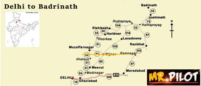
Road Map with Directions and Distance:
Here are a few routes that one could decide on taking:
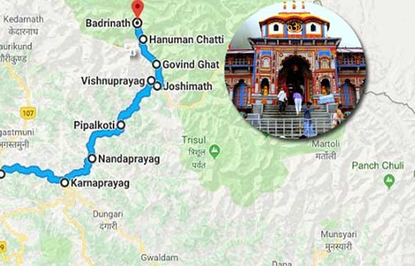
Route 1 – Haridwar / Rishikesh to Badrinath
Haridwar – (24 km) Rishikesh – (71 km) Devprayag – (30 km) Kirtinagar – (4 km) Srinagar – (34 km) Rudraprayag – (20 km) Gauchar – (12 km) Karnaprayag – (20 km) Nandprayag – (11 km) Chamoli – (8 km) Birahi – (9 km) Pipalkoti – (5 km) Garur Ganga – (15 km) Helang – (14 km) Joshimath – (13 km) Vishnu Prayag – (8 km) Govind Ghat – (3 km) Pandukeshwar – (10 km) Hanuman Chatti – (11 km) Badrinath Dham
Route 2 – Kedarnath to Badrinath (via Chopta)
Guptkashi – (20 km) Ukhimath – (22 km) Dugalbitta – (7 km) Chopta – (27 km) Mandal – (8 km) Gopeshwar – (10 km) Chamoli – (96 km) Badrinath Dham Mandir
Route 3 – Kedarnath to Badrinath
Kedarnath – (14 km) Gaurikund – (8 km) Sonprayag – (5 km) Rampur – (9 km) Phata – (14 km) Guptkashi – (7 km) Kund – (19 km) Augustmuni – (9 km) Tilwara – (8 km) Rudraprayag – (20 km) Gauchar – (12 km) Karnaprayag – (20 km) Nandprayag – (11 km) Chamoli – (8 km) Birahi – (9 km) Pipalkoti – (5 km) Garur Ganga – (15 km) Helang – (14 km) Joshimath – (13 km) Vishnuprayag – (8 km) Govindghat – (4 km) Pandukeshwar – (10 km) Hanuman Chatti – (11 km) Shri Badrinath ji Mandir.
Badrinath Overview
Area
Geo Location
Population
Average Climate
State
District
Language
Best Time to Visit
Pin Code
STD Code
3 km2 (1 sq mi)
North India
2,438 (2011)
-5 °C - 10 °C
Uttarakhand
Chamoli
Hindi, Garhwali, Kumauni
April to November
246422
01381
